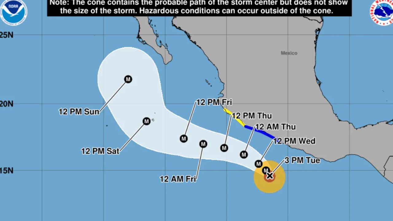
United States — Americans traveling to Mexico are being urged to closely monitor weather conditions as Hurricane Polo has rapidly intensified into a Category 5 major hurricane in the eastern Pacific, bringing the potential for dangerous rain, flooding, powerful winds and hazardous ocean conditions.
Hurricane Polo was packing maximum sustained winds of 180 mph Tuesday afternoon and was located about 215 miles south of Zihuatanejo, Mexico, according to the latest National Hurricane Center update.
Although the current forecast does not show Polo making landfall through at least Sunday, the powerful hurricane is expected to produce significant impacts along parts of Mexico’s southwestern coast before potentially approaching the Baja California Peninsula.
U.S. Issues Weather Alert for Mexico
The U.S. Department of State’s Consular Affairs issued a weather alert Tuesday afternoon as Polo continued strengthening over the eastern Pacific.
The warning specifically highlighted the potential for heavy rainfall, life-threatening flooding, mudslides, dangerous surf and deadly rip currents.
The State Department said:
“Mexico: Hurricane Polo, a Category 5 storm with sustained winds of 165 miles per hour, will cause heavy rainfall and hazardous ocean conditions along the southwestern coast of Mexico from Tuesday through Thursday,” the post on X said. “Hurricane Polo is projected to approach the southern tip of the Baja Peninsula on Saturday September 26 or Sunday September 27. Heavy rain may produce life-threatening flooding and mudslides. Hazardous ocean conditions may result in deadly rip currents and rogue waves. Avoid entering the water or walking on beaches during dangerous conditions, heed warnings from local authorities, and monitor official weather updates closely.”
The alert means Americans currently in Mexico or planning travel to potentially affected areas should pay close attention to official local warnings and changing forecasts.
Polo Becomes One of the Strongest Eastern Pacific Hurricanes
Polo’s rapid intensification has also placed the storm among the most powerful hurricanes ever observed in the eastern Pacific.
Its central pressure fell below 890 millibars Tuesday, making it the second-strongest hurricane recorded in the basin based on minimum central pressure.
MyRadar Weather highlighted the storm’s extraordinary strength, posting:
“Hurricane Polo is now the second strongest hurricane EVER recorded in the eastern Pacific! It’s air pressure is BELOW 890 MILLIBARS! That’s virtually unheard of!”
Another unusual feature of Polo was its exceptionally warm eye. The temperature inside the eye was reportedly around 29 degrees warmer than the surrounding atmosphere, a sign of the extremely intense conditions within the hurricane.
Patricia Remains the Eastern Pacific Record Holder
The strongest hurricane ever recorded in the eastern Pacific remains Hurricane Patricia, which formed in 2015.
Patricia reached a minimum pressure of 872 millibars and produced maximum sustained winds of 215 mph. The National Hurricane Center said the storm directly caused two deaths.
Polo has not surpassed Patricia’s record, but additional strengthening was still possible Tuesday night.
The NHC said:
“Some additional strengthening is possible tonight, with fluctuations in strength possible Wednesday and Wednesday night.”
Whether Polo ultimately challenges Patricia’s record will depend on how the hurricane evolves over the next several days.
Mexico Faces Heavy Rain and Dangerous Ocean Conditions
Even if Polo remains offshore, the storm could produce serious impacts along Mexico’s southwestern coast.
The NHC warned that heavy rain could affect Guerrero and Michoacán through Thursday, while tropical-storm-force winds could reach parts of Mexico as early as Wednesday.
The greatest hazards may not come from direct landfall. Powerful surf, dangerous rip currents and large waves can threaten beaches well away from the hurricane’s center.
Officials are also concerned about flash flooding and mudslides, particularly in areas where heavy rainfall falls over mountainous terrain.
A Powerful Nor’easter Is Coming: This Weekend’s Full Moon Could Make Coastal Flooding Worse
Polo Could Approach Baja California This Weekend
The latest forecast indicates Polo should remain offshore as it moves generally toward the Baja California Peninsula.
By Saturday, Sept. 26, or Sunday, Sept. 27, the hurricane is projected to approach the southern tip of Baja California. Current forecasts indicate Polo could still be a major hurricane by Sunday, although its exact strength and track could change.
For travelers, the situation could mean changing flight plans, dangerous beach conditions or disruptions in coastal areas depending on how close Polo passes.
The U.S. travel alert urges people to avoid entering the water or walking on beaches during dangerous conditions and to follow instructions from local authorities.
Anyone in or traveling toward affected parts of Mexico should continue monitoring official weather information as Hurricane Polo moves closer to the Baja Peninsula.
Are you traveling to Mexico this week, or do you have family or friends in the affected areas? Share your thoughts and let us know how you’re preparing for Hurricane Polo in the comments.


2 thoughts on “Travel Alert Issued for Americans as Category 5 Hurricane Polo Explodes Near Mexico”