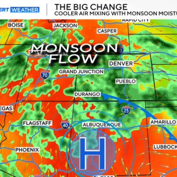
DENVER, Colo. — Colorado is set to wrap up August with cooler weather and a daily chance of rain showers and thunderstorms, offering some relief after recent warm spells.
Sunday Forecast
-
Denver Metro Area: Highs will reach the upper 70s to low 80s, slightly below the average 86°F for this time of year.
-
Mountain Towns: Expect highs in the upper 70s and low 80s under partly cloudy skies.
A cold front has moved into the state, pushing temperatures down and setting the stage for a cooler workweek ahead.
Rain & Storm Outlook
-
Sunday Afternoon: Another round of severe storms is possible, but the strongest activity is expected in the foothills, Palmer Divide, and Eastern Plains.
-
Monday & Tuesday: These are shaping up to be the wettest days along the Front Range.
-
Monday Morning: A slight chance of light showers for kids waiting at bus stops, but heavier rain is more likely after school hours.
-
Tuesday: The morning should start mostly dry, with rain and thunderstorms returning by early afternoon and lasting into the evening.
-
What to Expect
The combination of cooler temperatures and consistent storm chances will dominate the forecast heading into September. Residents should keep umbrellas handy and stay alert for localized flooding and possible severe weather on select days.
This article has been carefully fact-checked by our editorial team to ensure accuracy and eliminate any misleading information. We are committed to maintaining the highest standards of integrity in our content.

Katie is a senior who has been on staff for three years. Her favorite type of stories to write is reviews and features. Katie’s favorite ice cream flavor is strawberry.


Leave a Reply